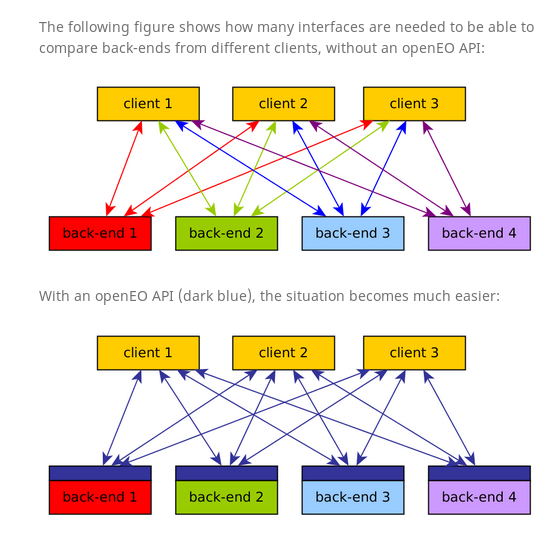
The OpenEO research project aims to make it easy to use Earth observation data from satellites to answer questions on land use, from environment and agriculture to biodiversity and ecology. Open source software plays a crucial role.
“We make all of our code publicly available as open source,” says Edzer Pebesma, Professor of Geoinformatics at the University of Münster. “That allows others to check the science in our methods. In addition, it lets them build upon our work.” Professor Pebesma and his colleagues hope this will encourage enough people to join the project to make its future services sustainable.
The three-year EU-funded project is almost halfway through, and
Analysing satellite data, mostly done through computer calculations, can become rather expensive. By making such queries easier there will be an increase in the number of questions, and that will bring down the prices charged by the data centres hosting the satellite data. “That means it becomes cheaper to repeat experiments, double-check calculations, or mix data from different satellites,” Professor Pebesma says. “That increases trust in the data and methods, which again will help create more demand.”
The first users of the OpenEO services will likely include other geoscientists, environmental agencies, and specialists working with land registries in the public sector. For them, the results will be decisions and actions that are supported by Earth observation information and services. However, the API can be used by anybody interested in using satellite data, including farmers, NGOs and journalists.
All source code for the OpenEO project is available on GitHub. That includes the specification for the API, with version 0.4 due on 15 February.