The European Space Agency (ESA) is an organisation that uses specialised software, which in most cases is custom-built by its contractors, or ESA itself. Being a public body, ESA provides its software to interested parties using different ways of licensing, including open source. The most popular ESA software packages are observation data processing and visualisation toolboxes, which make the Earth and space observation data more accessible to international research in biology, meteorology, geology and other sciences. This study presents different cases of software reuse provided by ESA, with special attention to the most popular open source software packages that are being reused in several circumstances throughout the world.
| Quick Facts | |
| Project Name | N/A |
| Sector | Space exploration |
| Start Date | N/A |
| End Date | N/A |
| Objectives | Reuse of ESA-produced software by its members’ public administrations and the public in general |
| Target group | Public sector; private sector |
| Scope | International |
| Budget | N/A |
| Funding | Internal funding |
| Achivements | Reuse of software built using public funding by as many as possible |
Introduction
The European Space Agency (ESA) is an international organisation that currently includes 18 member states. Due to the specialised nature of its activities, ESA is building specialised software for its own needs and to assist interested parties in taking advantage of the ESA products, especially imagery and observation data. This software is generally available under different types of license, including open source licenses.
ESA has a primary responsibility towards its member states and for this reason the primary type of license for ESA software is favourable for them. However, ESA is using open source licenses for some software, mainly related to Earth observation and science and it is considering applying OSS licensing to more software systems.
The main ESA product is observation data. For this reason, the most popular ESA software packages are data processing and visualisation toolboxes that make the data more accessible to international space research. It is important to note that space exploration does not only relate to space missions and extraterrestrial observation. Quite the contrary, a significant proportion of ESA data relates to Earth observations, which are especially important in biology, meteorology, geology and other sciences.
This case study presents examples of OSS software provided by ESA that has been reused by other organisations, such as universities, public administrations, etc.
Organisation and background
ESA is Europe’s gateway to space. Its mission is to shape the development of Europe’s space capability and ensure that investment in space continues to deliver benefits to the citizens of Europe and the world. ESA is an international organisation with 18 Member States. By coordinating the financial and intellectual resources of its members, it can undertake programmes and activities far beyond the scope of any single European country. The ESA Member States are: Austria, Belgium, the Czech Republic, Denmark, Finland, France, Germany, Greece, Ireland, Italy, Luxembourg, the Netherlands, Norway, Portugal, Spain, Sweden, Switzerland and the United Kingdom. Canada takes part in some projects under a cooperation agreement. Romania signed its Accession Agreement with ESA on 20 January 2011 and will soon become the 19th Member State. Hungary, Poland, Estonia and Slovenia are “European Cooperating States”. Other countries have signed cooperation agreements with ESA.
ESA’s relation to the European Union
The European Union (EU) and ESA share a common aim: to strengthen Europe and benefit its citizens. While they are separate organisations, they are increasingly working together towards common objectives. Some 20 per cent of the funds managed by ESA now originate from the EU budget.
ESA is an intergovernmental organisation, whereas the EU is supranational. The two institutions have indeed different ranges of competences, different Member States and are governed by different rules and procedures. However, in recent years the ties between the two organisations have been reinforced by the increasing role that space plays in supporting Europe’s social, political and economic policies.
The legal basis for the EU/ESA cooperation is provided by a framework agreement which entered into force in May 2004. Under this agreement the European Commission and ESA coordinate their actions through the Joint Secretariat, a small team of EC administrators and ESA executives. The Member States of the two organisations meet at ministerial level in the Space Council, which is a concomitant meeting of the EU and ESA Councils, organised by Member State representatives in the High-level Space Policy Group (HSPG).
ESA maintains a liaison office in Brussels to facilitate relations with the European institutions.
ESA and OSS
ESA produces software for its various functions. A growing number of software systems are provided by ESA as OSS and according to Mr James Eggleston of ESA, the organisation is consolidating licenses and governance issues in order to use OSS-like licensing schemes more for its software in strategic areas where this model promotes collaboration and industrial business cases. The main problem ESA encountered while trying to license software as OSS is the need to ascertain that all code included in custom-built software is indeed developed from scratch and does not include or make use of code already licensed under any incompatible license or software that may violate IPR licensing terms. In this direction, ESA is considering using a source code tracking system in order to identify code segments that may be already licensed within other OSS systems.
Apart from the problem of code origination, ESA is also considering the requirements established by OSS copyleft licenses used in software modules included within the ESA software and possible conflicts.
Budget and funding/Financial issues
ESA’s activities fall into two categories: “mandatory” and “optional”.[1]
Programmes carried out under the General Budget and the Science Programme budget are “mandatory”; they include the agency’s basic activities (studies on future projects, technology research, shared technical investments, information systems and training programmes).
All Member States contribute to these programmes on a scale based on their gross domestic product (GDP). The other programmes, known as “optional”, are only of interest to some Member States, who are free to decide on their level of involvement.

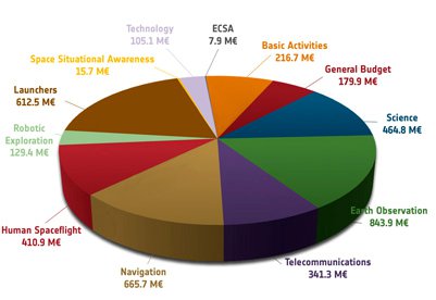
Figure 1: ESA budget by programme for 2011 (M€: Million Euro)
Source: European Space Agency
Optional programmes cover areas such as Earth observation, telecommunications, satellite navigation and space transportation. Similarly, the International Space Station and microgravity research are financed by optional contributions.
Reuse examples
These are examples of ESA software provided as OSS. For each package a brief description of its functionality, licensing and information about its use by other organisations is provided
POLSARPRO
POLSARPRO is a package that offers tools for manipulating SAR polarimetric [2] data. It also includes educational material about SAR[3] polarimetry. The tool has been specifically designed to handle polarimetric and polarimetric interferometric data including those from ESA third party missions (ALOS PALSAR), Envisat ASAR Alternating Polarisation mode products, RADARSAT-2 and TerraSAR-X. It is educational software that offers a tool for self-education in the field of polarimetric SAR data analysis and a comprehensive suite of functions for processing, analysis, scientific exploitation of fully and partially polarimetric data and the development of applications for such data. It was developed to be accessible to a wide range of users, from PhD students to experts in the field of polarimetry.
POLSARPRO is handling data from several different airborne and spaceborne platforms and as such it is a valuable tool for the study and observation of polarimetric data. It is available for a variety of platforms, both proprietary and open source.
The software is licensed under GPL v2.
Regarding reuse by other organisations, several universities and researchers around the world use it, such as the University of Rennes 1 in France and the Tor Vergata University in Italy. Researchers from the University of Alaska in the US, the Indian Institute of Technology in India, Defence R&D Canada, and other researchers around the world use POLSARPRO for the processing of polarimetric data in several different application domains, as noted in scientific papers. POLSARPRO appears in the list of tools used by the University of Leicester as a research infrastructure application.
BEAM (Basic ERS & Envisat (A) ATSR and Meris Toolbox)
BEAM is an open-source toolbox and development platform for viewing, analysing and processing of remote sensing raster data. Originally developed to facilitate the utilisation of image data from Envisat\'s optical instruments, BEAM now supports a growing number of other raster data formats such as GeoTIFF and NetCDF as well as data formats of other EO sensors such as MODIS, AVHRR, AVNIR, PRISM, CHRIS/Proba and SMOS. The current release is 4.8.
The BEAM SMOS-Box project has been brought to life in order to support users of data acquired by ESA\'s Soil Moisture and Ocean Salinity (SMOS) mission. BEAM and the SMOS-Box are user tools which ESA/ESRIN are providing free of charge to the Earth Observation Community.
BEAM and the SMOS-Box are free software; it can be redistributed and/or modified under the terms of the GNU General Public License as published by the Free Software Foundation.
The BEAM/VISAT user interface makes use of the JIDE Swing components (docking and action framework). JIDE is not an open source product, but JIDE Software has granted a free developer license to the BEAM project. It is for exclusive use within the frame of the open source BEAM project.
The IES Institute of DG JRC has developed a module (processor) for BEAM in order to compute the Fraction of Absorbed Photosynthetically Active Radiation.
At the Department of Applied Geoinformatics and Cartography of Charles University in Prague, BEAM and NEST software packages have recently started to be utilised in the remote sensing courses to give students some alternatives to commercial (and costly) software packages.
The North Sea Mathematical Models (MUMM) of the Royal Belgian Institute for Natural Sciences (RBINS) in Belgium has used BEAM in order to process imagery to analyse Belgian coastal waters. Similarly, the Canada Centre for Inland Waters has used BEAM to assess algal products in Lake of the Woods.
NEST (Next ESA SAR Toolbox)
The Next ESA SAR Toolbox (NEST) is a user-friendly open source toolbox for reading, post-processing, analysing and visualising the large archive of data (from Level 1) from ESA SAR missions including ERS-1 & 2, ENVISAT and in the future Sentinel-1. In addition, NEST supports handling of products from third-party missions including JERS-1, ALOS PALSAR, TerraSAR-X, Radarsat-2 and Cosmo-Skymed.
NEST is licensed under GPL.
The NEST website has been reported to attract a world-wide audience, with the USA and Italy covering 25% of the total number of visits and another fifteen countries accounting for an additional 50%.
At the Department of Applied Geoinformatics and Cartography of Charles University in Prague, BEAM and NEST software packages have recently started to be utilised in the remote sensing courses to give students some alternatives to commercial (and costly) software packages.
A Radar Remote Sensing Course co-organised by the Polish Academy of Sciences in Poland used NEST as part of the infrastructure necessary for the course.
EnviView
EnviView is a free application, which allows Envisat data users to open any Envisat data file, and examine its contents. It provides simple visualisation capabilities, and allows data to be exported to HDF for use in other software packages. Currently, ESA has stopped development on EnviView and suggests that the newer BEST, BEAM, BEAT, and NEST tools are used instead.
The EnviView software has been used by the Mullard Space Science Laboratory (MSSL) at University College London, UK.
BEAT (Basic ENVISAT Atmospheric Toolbox)
The Basic ENVISAT Atmospheric Toolbox project (BEAT) aims to provide scientists with tools for ingesting, processing and analysing atmospheric remote sensing data.
The project consists of several software packages, with the main packages being BEAT and VISAN. The BEAT package contains a set of libraries, command line tools, and interfaces to IDL, MATLAB, Fortran and Python that allow you to access data from a range of atmospheric instrument product files. The VISAN package contains an application that can be used to visualise and analyse the data that you retrieve using the BEAT interface.
The primary instruments supported by BEAT are GOMOS, MIPAS, and SCIAMACHY (ENVISAT), GOME (ERS-2), OMI, TES and MLS (Aura), and GOME-2 and IASI (MetOp).
BEAT is provided as open source software under the GPL license, enabling user community participation in further development and quality improvement.
The NERC Earth Observation Data Centre, UK is using BEAT and EnviView to access SCIAMACHY data. Researchers from Italy and USA are using BEAT and in fact augment its functionality by building additional modules, such as the GMTR Analysis System. The BEAT software is used by MIPAS research groups at different universities and research centres, such as the Karlsruhe Research Centre, Germany, the MIPAS group at Oxford University, UK, the Belgian Assimilation System of Chemical Observations from ENVISAT, Belgium, the Italian Istituto di Fisica Applicata "Nello Carrara", and Leicester University, UK.
Cooperation with other public bodies
The fundamental goals of ESA focus on the creation and transfer of technology towards the space industry in Europe. However, the breadth of ESA activities have extended the collaboration of ESA to include also other research organisations in Europe and worldwide.
In addition, ESA, being an international organisation mostly within the limits of the European Union, has close relations with the European Commission. These relations range from the co-financing of research and development of innovative solutions and technological problems related (among others) to space observation and missions, to the provision of know-how and technological means for all space-related activities of the European Union member states.
It should also be noted that ESA technology transfers has influenced economic sectors that are less related to space exploration, such as the automobile industry, geology, biology, health care, etc.
Evaluation, including lessons learned, and future plans
ESA is trying to establish a balance between two opposing forces: the need to acknowledge intellectual property rights of third parties (including the ESA contractors) and the responsibility for its member states that should be able to benefit from ESA activities, including software development. For this reason, there are different rules governing the contracted work depending on the source of funding. “Fully funded” contracts (i.e., projects funded in full by ESA) allow more possibilities in software licensing by ESA, as long as they do not conflict with the intellectual property rights of its contractors. However, partially funded contracts (i.e., contracts where the contractor and ESA contribute equally) offer fewer opportunities for the use of the resulting software.
It is important to note that ESA open source software is regularly used by research organisations throughout Europe and elsewhere. In this process, the open source ESA software evolves with the voluntary contribution of new and improved modules built by third parties.
Regarding the future, ESA is considering increasing the number of software packages licensed under OSS licenses and they have realised that this process is far from easy. In addition to the well-known OSS license implications of copyleft and permissive licenses, ESA faces an additional concern: Most ESA software is being developed by contractors, and consequently ESA does not have direct control over the development process. ESA needs to be able to verify the exact licensing status of every portion of the source code used within their software so that they can be certain that no license breaches are performed if they license their software under an OSS license and ultimately be responsible for it.
Links
In the following subsections references to ESA open source software reuse are presented. The links are grouped per software package.
POLSARPRO
- Garrett Parsons, Craig Williams, and Martin St-Hilaire: Analysis of Polar maritime data
- Varsha Turkar and Y.S. Rao: Supervised and Unsupervised Classification of PolSAR Images from SIR-C and ALOS/PALSAR Using PolSARPro
- Y. S. Rao, T. Dyuti, G. Venkataraman: ALOS PALSAR Quad-Pol Data for Soil Moisture Mapping
- Marco Lavalle, Domenico Solimini, Eric Pottier, Yves-Louis Desnos: The dependence of the PolInSAR degree of coherence on forest parameters
- University of Leicester: PolSARPro
BEAM and NEST
- Markéta Potůčková and Eva Štefanová: Utilization of BEAM and NEST open source toolboxes in education and research
- IES, JRC: FAPAR (BEAM Software)
- K. Ruddick, Y. Park and B. Nechad: MERIS Imagery of Belgian Coastal Waters: Mapping of Suspended Particulate Matter and Chlorophyll-A
- C. E. Binding, T. A.Greenberg, J. H. Jerome, R. P. Bukata and G. Letourneau: An assessment of MERIS algal products during an intense bloom in Lake of the Woods
- Andrea Minchella, L. Veci, Marcus Engdahl and Petar Marinkovic: NEST: the ESA toolbox for scientific exploitation of SAR data
- Programme of Radar Remote Sensing Course
EnviView
- MSSL, UCL: ENVISAT RA2 / MWR Product Handbook
BEAT
- NERC Earth Observation Data Centre
- E. Arnone, G. Brizzi, M. Carlotti, B.M. Dinelli, L. Magnani, M. Ridolfi, and E. Papandrea: MIPAS2D: 2-D analysis of MIPAS observations of ESA target molecules and minor species
Notes
- http://www.esa.int/SPECIALS/About_ESA/SEMNQ4FVL2F_0.html
-
Polarimetry is the measurement and interpretation of the polarisation of transverse waves, most notably electromagnetic waves, such as radio or light waves. (Source: Wikipedia)
- Synthetic Aperture Radar