In line with the European Data Strategy, a new report from the ISA² ELISE action titled "Establishing Sustainable Ecosystems" provides a set of recommendations to transform today's spatial data infrastructures into true self-sustaining data ecosystems.
The report lists up to 37 recommendations grouped into 4 themes:
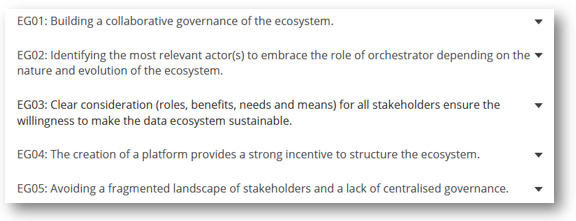
- Ecosystem governance
- Technical issues
- Stakeholders ’engagement
- Economic sustainability
These recommendations have been compiled in a dedicated web page of the ELISE collection to facilitate its navigability and discovery. You can start browsing here.
To download the full report click here.
Background:
This report is the main output of the activity funded by ELISE Data Ecosystems for Geospatial Data. The aim of this activity was to identify and analyse a set of successful data ecosystems and to come up with a set of recommendations in support of the evolution of contemporary Spatial Data Infrastructures in line with the recently published European strategy for data.
Each recommendation, validated by experts, describes a concrete action for modernizing how the INSPIRE Directive share and manage SDI data. These recommendations indicate challenges and best practices to turn current SDIs into self-sustained data ecosystems nurtured, not only, by the public sector and data providers, but also by its users and intermediaries.
The recommendations emerge from the in-depth analysis of five case studies analysed during the investigation.
- The local data ecosystem of Rennes Métropole and its Rennes Urban Data interface initiative.
- The Geospatial data marketplace by UP42 marketplace and developer platform.
- Tracking technologies for supply chain by SPIRE nanosatellites.
- The smart agriculture B2B data exchange platform API-Agro, operated by Agdatahub and a company made up of 30 partners.
- The disaster management ecosystem of the Brussels emergency services data-sharing platform and the Danish Common Data on Topography, Climate, and Water.
Two open workshops have been organised throughout the activity with stakeholders at:
- the INSPIRE Conference 2020 to gather views from the audience [event details, slides & recording].
- an ELISE organised workshop to validate the final recommendations [event details, slides & recording].