Check out the recording and supporting slides for the ELISE webinar - Digital Twins - Are they ready to embrace the benefits of Location Information?
If you are interested in knowing more about ELISE Rapid Studies and Webinars you can find further information here.
Structure of the presentation
- Context, definitions & frameworks
- Digital twin initiatives & applications
- Interoperability challenges of digital twins
- Key take-away messages and conclusions
Recording
Summary
The webinar on Digital Twins presented the state of play on developing and deploying digital twins in Europe and how they rely on geospatial data, data infrastructures and technologies. The webinar aimed to increase the participants’ understanding of the digital twin concept, introducing digital twin applications at different geographical levels. Moreover, the webinar highlighted how geospatial data, standards, and technologies are essential for creating and managing digital twins.
The webinar presentation started by discussing the context and relevant definitions and frameworks on digital twins. In the policy context, the European Data Strategy[1] underlines the importance of data to implementing digital twins: "data will fuel the wide implementation of transformative practices such as the use of digital twins". The academic literature shows a significant increase in the number of publications related to digital twins since 2017. This increase is in line with Gartner's 2018 Hype Cycle for Emerging Technologies[2], where digital twins were at the Peak of Inflated Expectations. Finally, the latest UN-GGIM vision report on Future Trends in geospatial information management named digital twins among the technologies playing a prime role in disrupting the geospatial domain[3].
The visibility of the digital twin notion has increased in recent years. However, the concept itself is not new. The core ideas behind digital twins were already introduced in 2002 with the notion of a "mirrored spaces model". In this model, the distinction between real space and virtual space is made, with exchanges and flows of data from the real space to the virtual space and a flow of information from the virtual space to the real space. This mirrored spaces model had all the key elements of today's Digital Twins. While the digital twin idea is commonly thought to have been developed in 2002, digital twin technology has been used since the 1960s. NASA used basic twinning ideas for space programming by creating physically duplicated systems at ground level to match the systems in space. Nowadays, digital twin applications exist in different domains and sectors, such as manufacturing, industry, space & aerospace, energy, construction, transport, healthcare and sports.
A digital twin can be defined then as an integrated simulation of a real-life system that uses models, sensor information and input data to mirror, predict and control the activities and performance of its corresponding physical twin[4]. Two essential elements stand out:
There is a connection between the physical model and the corresponding virtual model or virtual counterpart, and this connection is established by generating real-time data (e.g. through using sensors).
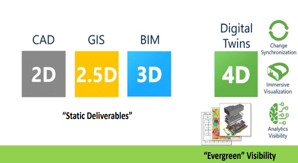
It is important to note that there are more simple forms of digital twins and more advanced ones. Elements that differentiate the simple digital twins from the most advanced ones include the frequency at which the virtual and physical twins are synchronised, the number of parameters, their accuracy and level of abstraction, the autonomy of the system, the intelligence of the system and the ability of the twin to learn from data automatically[5]. Identifying the key elements of digital twins allows understanding what digital twins are and comparing their development level. Figure 4 shows how digital twins fit into the evolution from 2D to 4D, including change synchronization, an immersive visualization and advanced analytics.
The second part of the presentation focused on digital twins that strongly rely on geospatial data and technologies, named "location-enabled digital twins" in this webinar. Several digital twin applications and initiatives supporting the development of these applications were presented. These included the European Commission plans to develop a digital twin of the Earth and a digital twin of the ocean; national initiatives to build country-wide digital twins[7]; and digital twins of cities, buildings and the underground[8]. Initiatives to develop and use location-enabled digital twins exist at different levels, with different scales and application fields. These digital twins are used for various purposes, such as running simulations and preparing what-if scenarios, i.e., investigating the outcomes of changes in particular parameters.
The third part of the webinar presentation addressed the interoperability challenges of digital twins. An overview of geospatial datasets essential for digital twins was provided, including geometric and graphical data, geospatial reference data, asset attributes (natural, physical, social, economic), management data and real-time asset performance and utilisation data[9]. Based on the minimum capabilities (connection, visualisation, integration, analysis and security), a digital twin has to provide several geospatial technologies and developments that are crucial to developing location-enabled digital twins. Some of these are spatial data infrastructures, sensor web enablement, geo-visualisation, GeoAI and secure access mechanisms. Digital twins also require new ways to handle data as static and dynamic data need to be combined.
Furthermore, 2D, 3D, and 4D data and models are needed. Interactions between different elements are important, and the real world should be modelled and simulated. The latter not only requires a lot of power but also brings many interoperability challenges. In conclusion to this part of the webinar, it was mentioned that technical, semantic, organisational and legal interoperability remain critical requirements for the successful development of digital twins. Standardisation bodies in the geospatial domain are aware of these requirements and are already actively working and collaborating on effective ways to address them. Several local and regional governments are also collaborating to prepare solutions for achieving interoperability of data, systems, and services between cities through 'simplified' standards and common building blocks.
In the fourth and final part of the presentation, key challenges and priorities for the future were presented. Existing spatial data infrastructures & ecosystems should evolve and be upgraded to enable the creation and use of location-enabled digital twins. As different communities are looking at and/or dealing with digital twin developments, it is essential to bring these communities and involved actors together. The creation and operation of these digital twins also require new skills and competencies, which should be identified first and afterwards introduced in existing or new education and training programs.
Key messages and conclusions
Key messages:
- Geospatial data, tools and technologies should be seen as the fuel to digital twins at different levels and in different domains
- Further investigation and assessment is needed of the current state of geospatial data, standards and technologies relevant to Digital Twins
- Existing spatial data infrastructures & ecosystems should be further upgraded to enable the creation and use of digital twins
The webinar highlighted several aspects of digital twins as a driver of innovation and digital transformation. The idea of using virtual models to optimise products and services and develop new products and services is not new. Compared to these virtual models, digital twins are different in many ways. There is the real-time data connection – in both directions – between the digital twin and the physical twin, the increased number of parameters with higher levels of accuracy and abstraction, and very high levels of intelligence and autonomy.
Digital twins create a virtual replica of a physical product or process that can predict when the production or maintenance of this product will fail. An important innovation provided by these digital twins is the advanced simulation capabilities. Highly complex what-if simulations can be designed, considering real-world conditions and allowing to perform vast numbers of simulation processes. Looking at the public sector will enable new ways of policymaking and public service delivery and transform the underlying processes and practices of public administrations.
The webinar strongly focused on the interoperability challenges and solutions required for making this innovation and transformation possible. Semantic, technical, organisational and legal interoperability are key requirements for developing individual digital twins and will become even more essential for the integration of different digital twins. Interoperability solutions developed and applied in the geospatial data domain, such as the standards developed and promoted by the relevant Standards Developing Organisations (SDOs) and used in many Spatial Data Infrastructures, could contribute to addressing these interoperability challenges, but additional interoperability efforts are required. To illustrate this, the ISO/IEC JTC 1/AG 11 Digital Twin Working group defined a set of tasks to better prepare standardisation activities on digital twins. These include identifying current technologies and reference models deployed in digital Twins, assessing the current state of standardisation activities relevant to digital twins, identifying standardisation issues of Digital Twin to be addressed further, and engagement and collaboration with standards-setting organisations that are involved in digital twins standardisation.
Important to notice is that not only the SDOs are looking at and working on the interoperability challenges of digital twins. Various local, regional and national governments are collaborating on solutions to address these interoperability challenges jointly. One solution is the so-called Minimal Interoperability Mechanisms (MIMs), which aim to achieve interoperability based on a minimal common ground.
[1] https://ec.europa.eu/info/strategy/priorities-2019-2024/europe-fit-digital-age/european-data-strategy_en
[2] https://www.gartner.com/smarterwithgartner/5-trends-emerge-in-gartner-hype-cycle-for-emerging-technologies-2018/
[3] https://ggim.un.org/future-trends/
[4] Definition based on: Kraft, E. M. (2016). The air force digital thread/digital twin-life cycle integration and use of computational and experimental knowledge. In 54th AIAA Aerospace Sciences Meeting (p. 0897).
[5] https://www.arup.com/-/media/arup/files/publications/d/digital-twin-report.pdf and https://www.theiet.org/media/4719/digital-twins-for-the-built-environment.pdf
[6] Bentley, B. (2019). The Year in Infrastructure 2019 Awards. Bentley Systems, Singapore, 2019.
[7] https://www.geonovum.nl/over-geonovum/actueel/geosamen-wijs-met-locatie-werkplaats-digital-twin
[8] https://digitalunderground.sg
[9] https://www.anzlic.gov.au/resources/principles-spatially-enabled-digital-twins-built-and-natural-environment-australia