Last update: 28/06/2024
Interoperability Test Bed
ToolsReusable Software Components+3 topics
The Test Bed has now made available a new service to validate JSON geographical data against the GeoJSON specification.
The GeoJSON specification foresees the necessary object types and properties to express spatial data in JSON, including definitions for concepts such as polygons, points and features. The GeoJSON Working Group, involving the Internet Engineering Task Force (IETF) and the original specification’s authors, standardised GeoJSON resulting in RFC 7946 being published as the latest specification version in August 2016.
The Test Bed now supports projects using GeoJSON to express spatial data by making available a new validator to validate JSON content against the GeoJSON specification. Validation can be targeted to specific GeoJSON types or the complete specification, supporting also additional user-provided JSON schemas to include checks on a given project’s specific extensions.
The validator is accessible via the following channels:
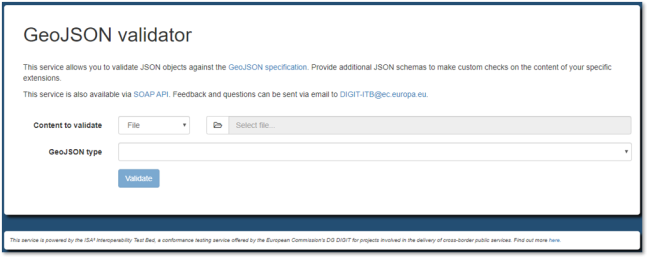
The GeoJSON validator is a validator instance that reuses the Test Bed’s core JSON validation service. For more information on how JSON-based validators can be configured and used be sure to check the detailed JSON validation guide, part of the Test Bed’s online guides and tutorials.
For more information on the Test Bed itself check its Joinup space with its value proposition being a good starting point for newcomers. Finally, to remain updated of all the latest Test Bed news: